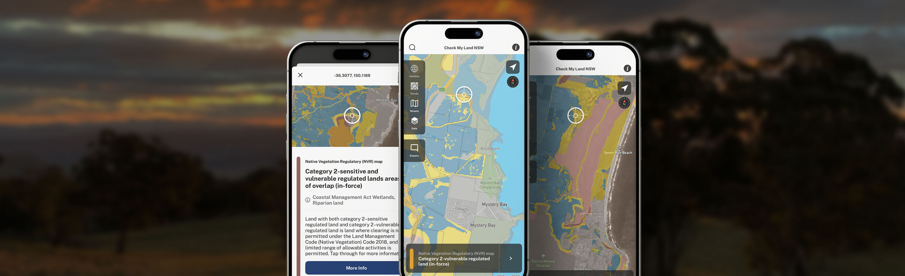
The Check My Land NSW app allows you to explore the draft NSW Native Vegetation Regulatory map and use the map to support your land management decisions.
Find your area of interest to view the land categories mapped in the location. The app also provides more detailed information about the land category applied to each area.
About the Check My Land NSW app
The Check My Land NSW app helps you make informed decisions about land management.
The app displays the draft Native Vegetation Regulatory Map (NVR Map). The map provides important information for landholders making decisions about clearing vegetation in accordance with NSW legislation.
The app includes links to useful resources that can further assist you.
More information can be found under the ‘i’ icon at the top right-hand corner of the application home screen.
Note: The app uses location services in your device to position your location on the map, or you can search or zoom to a specific location.
The draft NVR Map is a guide to support your land management decisions. You may need to seek further information or advice, or undertake on-ground assessment before proceeding with a land management activity.
About the Native Vegetation Regulatory (NVR) Map
What is the purpose of the Native Vegetation Regulatory Map?
The Native Vegetation Regulatory (NVR) Map is a key tool in the NSW Land Management Framework that supports landholder decisions about clearing native vegetation. Currently, the draft NVR Map is available for landholder consideration. The NVR Map will be published when the review period ends.
The role of the NVR Map is to regulate the management of vegetation on rural land. The NVR Map designates areas of land where clearing of vegetation is categorised as regulated or exempt under the Local Land Services Act 2013. Some areas in NSW are not subject to the LLS Act and are identified as excluded land.
All services relating to reviews of the NVR map will continue to be available after the publication of the final map.
When should I consider the Native Vegetation Regulatory Map?
If you are considering clearing vegetation on your rural land, you can:
- view the draft map and use the draft map to guide your decision making
- learn about what the land categories mean, and what you can do in these areas by requesting a free category explanation report
- request a free map review now or at any time in the future. If you think the draft map is inaccurate in specific areas you can contact us and supply more information, which will be assessed in accordance with the land category criteria specified in the Local Land Services Act.
What land categories are displayed on the Native Vegetation Regulatory Map?
The NVR map displays the land categories outlined in the existing legislation that has been in place since 2017 (the Local Land Services Act and Local Land Services Regulation).
There are 6 different colours you might see on your map:
Category 1 exempt land (blue) is land where native vegetation can be cleared without approval from Local Land Services. Note: Approvals may be required under other legislation in some circumstances.
Category 2 land is divided into:
- category 2 -regulated land (yellow) is category 2 land that is not Vulnerable or Sensitive regulated land. You may need authorisation from Local Land Services to clear native vegetation in this category. A range of allowable activities can be carried out without authorisation.
- category 2–vulnerable regulated land (orange) is land where clearing of vegetation may be limited under the Land Management (Native Vegetation) Code 2018. A limited range of allowable activities are permitted.
- category 2–sensitive regulated land (pink) is land where clearing is not permitted under the Land Management Code (Native Vegetation) Code 2018. A limited range of allowable activities is permitted.
Excluded land (grey) is land where Part 5A of the Local Land Services Act does not apply. Other legislation may regulate clearing activities on this land.
Each land category is determined by various criteria as outlined in the Local Land Services Act 2013. Detailed information about the criteria applied to each land Category can be found on our Map Categories webpage.
More information can be found in the Draft native vegetation regulatory map guide.
What if I disagree with the Native Vegetation Regulatory mapping on my property?
If you have concerns about how the draft NVR Map categorises your land, you can seek advice from the DCCEEW Map Review Team, including a free category explanation report or a free map review.
How do I apply for an explanatory report or a map review for my property?
Submit this form and the Map Review Team will contact you to discuss your needs and provide you with information about whether a map review or category explanation report are appropriate for your circumstances.
All map review services, reports and reviews are free and are available during consultation on the draft NVR map and after publication of the NVR map.
How does the Native Vegetation Regulatory Map support my land management decisions?
Simplifying self-assessment - The draft NVR map does not create new regulatory requirements or place additional requirements on you. While the draft native vegetation regulatory map is under review, land categories remain defined by the criteria in the legislation; the Local Land Services website includes resources that can assist. The draft NVR map is an additional resource.
Get on with business and operate with confidence - You can consider the draft NVR map when making decisions about vegetation management. If the areas mapped as draft category 1 (exempt) land meet the Local Land Services Act criteria, native vegetation clearing is not restricted under the Act in those areas.
Approvals may be required under other legislation. Refer to the LLS Factsheet (Obtaining other approvals - Managing Native Vegetation) for further information.
Discover economic opportunities - You may own areas mapped as sensitive, vulnerable or category 2 (regulated) land, which are natural capital assets that could generate economic benefits. These areas can potentially provide economic opportunities, including:
- biodiversity credits: generating biodiversity credits for sale through the Biodiversity Credits Supply Fund
- carbon credits: receiving incentives and private equity through carbon trading schemes
Where do I go for help?
Spatial Services and Customer Delivery – Map Review Team
If you need assistance using the Native Vegetation Regulatory map or the Check My Land App please contact the Map Review Team on 1800 001 490 or email map.review@environment.nsw.gov.au.
Local Land Services
If you require more information about land management, allowable activities that may be available to you or for approval to clear native vegetation on regulated land contact your regional Local Land Services office or call 1300 795 299.
Contact the Map Review Team
You can submit an enquiry to the Map Review Team for an explanation report, map review or general enquiry.
To provide feedback about Check My Land NSW App, select 'General Enquiry' and 'Other' in the form.
Click on the link below to proceed to the website form.
Data custodianship
The Check My Land app displays the current NSW Native Vegetation Regulatory Map data as held by NSW DCCEEW.
The Check My Land NSW app is a project of the NSW Department of Climate Change, Energy, the Environment and Water.
The NSW Department of Climate Change, Energy, the Environment and Water works to protect the state’s environment and heritage. It leads the way on climate change, driving the sustainable transition to a net zero economy, powered by affordable, reliable, and clean energy. The DCCEEW website is https://www.nsw.gov.au/departments-and-agencies/dcceew
App Recognition
This app was developed by the Science and Insights Division of the Department of Climate Change, Energy, the Environment and Water
Photo Credits
Thank you to the following DCCEEW photographers:
Title page - Victoria Lees, DCCEEW
Intro screen one - Lachlan Copeland, DCCEEW
Intro screen two - Victoria Lees, DCCEEW
Intro screen three - Rod Campbell, Uncapped Creative
Published by
Department of Climate Change, Energy, the Environment and Water
Locked Bag 5022, Parramatta NSW 2124
Phone: +61 2 9995 5000
Phone: 1300 361 967 (Environment and Heritage Group)
TTY users: phone 133 677, then ask for 1300 361 967
Speak and listen users: phone 1300 555 727, then ask for 1300 361 967
Email: info@environment.nsw.gov.au
Website: www.environment.nsw.gov.au
Report pollution and environmental incidents
Environment Line: 131 555 (NSW only) or info@environment.nsw.gov.au
Copyright
© State of New South Wales (Department of Climate Change, Energy, the Environment and Water) (unless otherwise indicated).
Unless otherwise stated, Department material available on this application or website is licensed under Creative Commons Attribution 4.0 International (CC BY 4.0) or Creative Commons Attribution-NonCommercial 4.0 International (CC BY-NC 4.0). Terms and conditions of the licences can be viewed at Creative Commons (CC BY) and Creative Commons (CC BY-NC).
The Department of Climate Change, Energy, the Environment and Water asserts the right to be attributed as author of the original material in the following manner: "© State Government of NSW and Department of Climate Change, Energy, the Environment and Water 2024". We also request that you observe and retain any copyright or related notices that may accompany this material as part of the attribution.
Privacy statement
The Department's privacy practices are regulated by the Privacy and Personal Information Protection Act 1998 (NSW) (PPIP ACT) and the Department's Privacy Management Plan (PMP).
Collection of your Personal Information
The Department does not collect any personal information to deliver our App. You may, when prompted by your device, share your location with the App. This information is not stored. If you choose not to share your location with the App you will still have access to all features, except being able to locate your position in the map.
Anyone engaged to collect, store or use personal information for the Department will be required to comply with the PPIP Act and the Department’s Privacy Management Plan.
Please note that the Department does not have any responsibility for the privacy policies or practices of third party sites linked to this website.